Tony and Dawnelle GuentherJoin us as we explore our beautiful province. Archives
April 2022
|
Back to Blog
Ancient Art8/6/2022 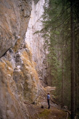 "This doesn't look right." I said to Tony. We had been searching for a while and I was giving up hope that we would ever find what we were looking for. The forest was so thick around us and we saw nothing but lodgepole pines. "Maybe there." Tony said, pointing to a small pullout beside the gravel road. Once we exited the truck we spotted a path that wove into the forest. We followed the trail, past some enormous boulders and over a small hill and then there it was. The limestone cliff was enormous and unexpected, towering far above us. 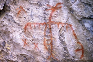 Thunderbird Thunderbird I searched the rock face hoping that this was the place and it didn't take long to confirm that we were in the right spot. After much research we had found what we had been looking for; one of the largest thunderbird pictographs in British Columbia. It took my breath away.  Long before there were GPS units and iphones, we relied on backroad maps to guide us as we explored British Columbia. During one of our earliest trips I noted a small star on a map. Beside the star was the word "pictograph." Hmmm. Tony and I are both artists so the thought of finding ancient works of art was immediately intriguing; but finding them was like finding a needle an haystack. Then, in 1986, CHBC began airing a local television show called "Gold Trails and Ghost Towns." For ten seasons BC historian Bill Barlee regaled host Mike Roberts with fascinating tales of BC's history. He would often tell stories of finding beautiful paintings; giving small clues as where to look. We were hooked. 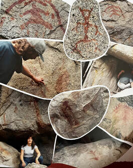 The first pictographs we found were on Old Hedley Road. Before Highway 3 (the Hope-Princeton) was constructed, travellers going between Hedley and Princeton used the wagon road that hugs the north bank of the Similkameen River. Approximately 30 km in length, the Old Hedley Road is often referred to as the "pictograph stretch". Approximately 50 paintings can be found along the road, many visible from your car. You just need to slow down. Some of my favourite paintings can be found in this area including; Deer Corral, Mars and Stepping Stones (Drowned Warrior.) There are hundreds of documented paintings in BC. Some of the earliest research & recordings were done by anthropologist James Teit (1864-1922) and John Corner, who published Pictographs (Indian Rock Paintings) in the Interior of British Columbia in 1968. 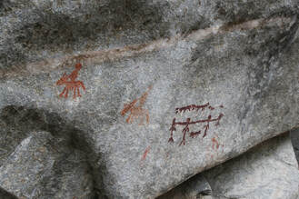 Many articles discuss possible meanings and many theories exist on how they were able to make such durable paint! We are not experts, just two people who love exploring our province. What fascinates us are the untold stories! In his book, Corner tells of a pictograph on the shores of Okanagan Lake depicting a strange creature known by the local people as "Na-ha-ha-itkh" - the water god. Was this an early depiction and evidence of the legendary Ogopogo?! Another set of pictographs (near Hedley) clearly shows 4 men bound together by their necks. The prisoners are surrounded by men (with hats) on horseback and what appears to be four dogs. There are a few theories as to what this collection of paintings could mean but I like Bill Barlee's theory best. Based on oral history, many clues and artifacts, Barlee speculated that a Spanish armada travelled up the Columbia River in approximately 1750. Sometime during their travels they captured some of the local Similkameen people to use as forced labour. Chaining their captives together by the neck and using guard dogs was unfortunately a common practice. After a brutal winter the Similkameen took their revenge. They ambushed the now decimated armada and a massacre took place. According to legend, the Similkameen buried almost all the evidence of the Spaniards -- men, horses and weapons -- somewhere near Olalla. Could these paintings be a clue to the legendary missing Spanish Mound?! After finally finding a site and to see that someone has spray painted over it or attempted to chip it away just breaks my heart. These ancient works of art are part of our living museum and unfortunately there are those who don't give them the respect they deserve. For that reason I am reluctant to give precise locations for the sites that we have found. If you are fortunate enough to find a pictograph site, take a moment to envision the artist. Was he a shaman praying in a cave? A friend mourning the loss of a brother? A traveller marking the way for others? There are so many mysteries surrounding these ancient works of art and we will never know exactly what they mean. What is important is that all pictograph sites are an integral and precious piece of British Columbia's amazing, beautiful and yes, sometimes sorrowful history. OUR PICTOGRAPH GALLERY - All the pictograph photos in this blog are our own. Please do not use without permission.
0 Comments
Back to Blog
Picture the Past6/7/2022 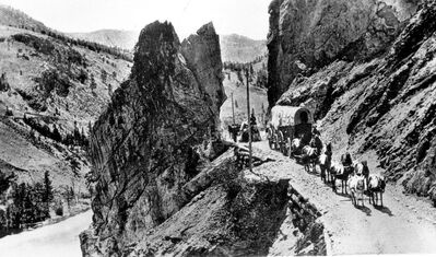 During the past 40 years Tony and I have spent a crazy amount of time researching our home province of British Columbia. We've studied many old maps, the flora and fauna, its geology and, of course, its colourful history. Somewhere, during our research, we came upon this photo (left). Taken by Frederick Dally in 1868, it beautifully captures an eight-mule team pulling a freight wagon on the Yale-Cariboo Wagon Road. Not only does this picture capture the era so well but, when I first saw it, I immediately recognized where it had been taken. Approximately thirteen kilometres north of Spences Bridge, we have travelled through the Great Bluff many times, but in my family it's simply called "mom's spot." Over one hundred and fifty years have passed since wagons travelled this road, yet this part - now a busy highway - has changed very little. Every time we pass through it I experience a little pull into the past. Everyone in my family knows; there is no talking when we drive through the spot. I need quiet to savour the moment. While I love nothing better than digging through history and and visiting every small town museum, Tony will tell you that there is nothing like experiencing history right where it happened. So it was not surprising when he came up with the idea to recreate my favourite photo with our faithful Ford.  Easier said than done. I was excited about the idea! Every time we travelled through my spot we discussed a possible plan, but the logistics of recreating Dally's photo were proving far more difficult than we expected. From the original photo, we figured that Dally had taken his picture from a small, but steep side-hill between the road and the river. That sidehill is still there, but getting to it was the problem. First, there is no shoulder to speak of on this stretch of highway; it's straight down to the river or straight up the mountain! Second, the days of slow moving wagon trains are long gone! Now we were dealing with fast moving semi trucks and tourists on a mission. There is a pull out about one km north of the spot but there was no way I could safely walk on the highway from there. What to do? Two weeks ago, we were on our way home from a weekend away in the Cariboo. This time, unlike every trip before, we came up with a plan and things seemed to be working in our favour; we were travelling alone, it was a Tuesday (less traffic) and it was sunny! Tony drove us south, through the spot and then pulled over. We waited until there was zero traffic and then he turned around, heading back north. "You'll have just a few seconds to get out." He said. "Be ready to bail!" With my trusty Canon looped around my neck and my iphone in my back pocket, I made ready to jump out as quickly as I could. Seconds after I slid out, I started to jump the concrete guardrail and climb the side-hill, when I heard a crunch. I turned, just in time, to watch our truck tires flatten my phone! I won't write what came out of my mouth at that moment but it wasn't pretty! Oh well.... focus on the task at hand. With my broken phone in one hand, I grabbed at sagebrush with the other and hoisted myself to the top of the hill. Once again, Tony turned the truck around to head through the spot. When he came close, I threw up my hands for him to slow down. He rolled down his window and I yelled from the top of the hill, "My phone is wrecked!" Now there was no way he could text when he was coming back for the photo. We had decided we'd give this one shot; we were going to have to wing it and hope for best. I trained my camera on the opening. Did I have the settings right? Was that him? It was so hard to tell so I took photos of every vehicle that came through. Finally, I spotted our truck with the familiar red boat on top. I managed to take three photos as Tony went by. We finally did it! 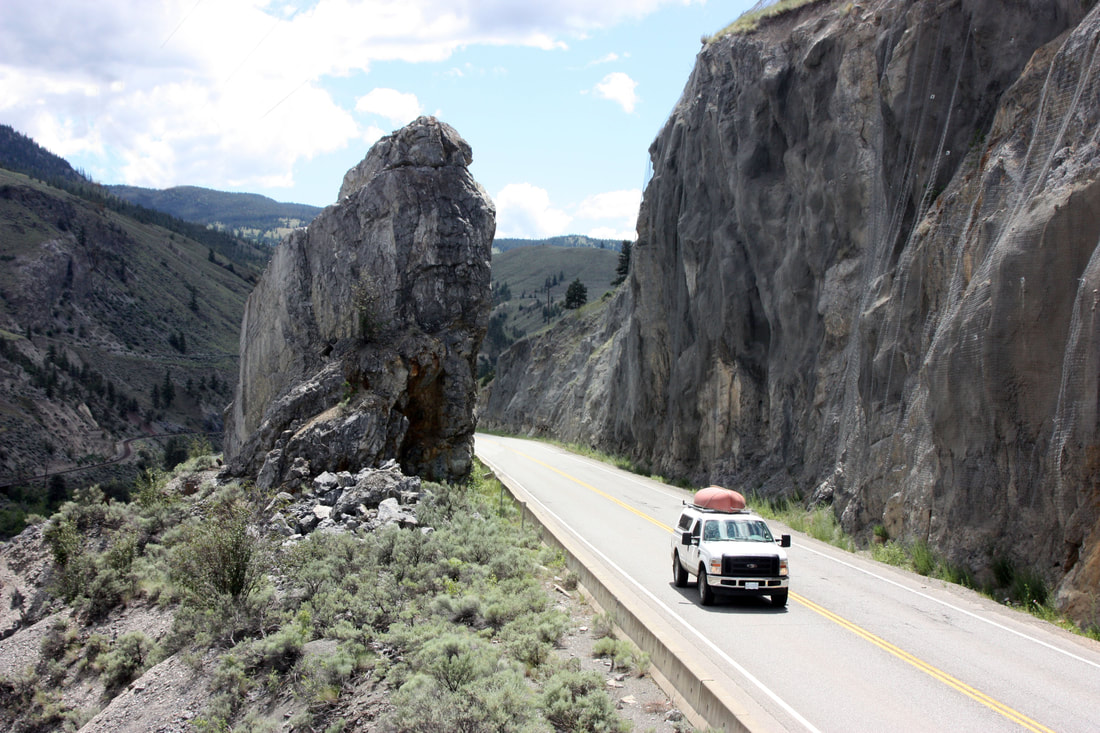 After writing this post, I had to ask myself if all our effort was worth one photo. Short answer? Absolutely. This is what the best memories are made of.
Back to Blog
Little Trip to the Prairie4/19/2022  I know, I know... this travel blog is dedicated to our backroad journeys of British Columbia but I had such a great time during my latest trip to Saskatchewan that just had to share. Before you say, "What's there to see on the prairies?" please allow me to sway you just a bit. The prairies may be flat but what it lacks in mountains and valleys, it more than makes up for with history, friendly people and small town charm. One of my dearest friends moved from BC to SK many years ago and we've done our best to stay connected. Since COVID began, I had not been out to see her in over two years, and so, when I was finally able to visit, she planned a four day road-trip for us that would include a stay at the Temple Gardens Mineral Spa in Moose Jaw. The name "Moose Jaw" does not exactly scream "resort town" does it? There are two possible explanations for the name; the river running through the town looks like the jaw of a moose or the name originates from the Plain Cree word moose gaw meaning warm breezes. I like the second explanation best. Either way, Moose Jaw is an unique destination that you don't want to miss. 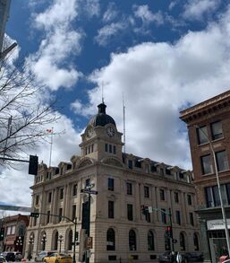 Moose Jaw was built in 1882 as a hub city by the CPR. It's believed that in 1908, Chinese immigrants, fleeing discrimination, abuse and the Canadian imposed Chinese Head Tax, built a network of tunnels underneath the city where they could live in relative safety. Later, during prohibition, these tunnels found a new use; a hideaway for gambling, prostitution and rum running. It's rumoured that many Chicago mobsters visited Moose Jaw in the 1920s, including Diamond Jim Brady and Al Capone himself. One hundred years later the stories and urban legends abound, resulting in Moose Jaw being dubbed "Canada's Most Notorious City." 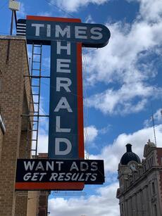 Today, walking down the streets of Moose Jaw is like turning back time. Neon signs still light up the streets and the buildings, while trendy inside, have been preserved to retain their historic vibe on the outside. Moose Jaw has something for everyone; for the foodie, the fashionista and the history buff. You can shop till you drop or chill all day. These are just a few of my recommendations: 
Thanks for taking this little side trip with me to one of my favourite prairie towns. Until next time...
Back to Blog
Finally...Back on the Road2/28/2022 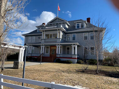 The Quilchena Hotel The Quilchena Hotel At the end of June 2021, an unprecedented heatwave hit the western coast of North America. Lytton, British Columbia, famously known as the "hotspot" of Canada, hit a record 49.6 C (121.3 F). On June 30th the beautiful historic village of Lytton burned to the ground. Throughout that summer, fires raged in every corner of our province. Thick smoke blanketed the Fraser Valley and many travel plans had to be cancelled as highway after highway was closed. Then, in November 2021 an atmospheric river poured a deluge of rain on the land. A month's worth of rain fell in just three days. The result was beyond anyone's imagination. Mudslides and flooding rivers decimated the Sumas Prairie and the towns of Princeton and Merritt. Needless to say, it was a tough year for those of us who call this place home. It's been far too long since Tony & I have been on a BC road trip and oh, how we missed it. Finally the roads are open; we found a few days to get away and so we decided to take a quick trip along the backroads to Kamloops. It was at Merritt that we veered off the main path. The Old Nicola Highway (Hwy 5A) is one of my favourite 'bypasses' and if you're not in rush to get to Kamloops I highly recommend this road that runs parallel to Nicola Lake, Stump Lake and so many more. First stop was the Quilchena Hotel. Built by Joseph Guichon in 1908, this historic building has been beautifully preserved and stepping through its doors is like stepping back in time. The hotel is still available to rent but on a limited basis. Tony & I were fortunate enough to celebrate our 10th Wedding Anniversary (1991) in the hotel's honeymoon suite. Our room was historically accurate to every detail. I especially loved the sign by the light switch that said "Do not attempt to light the fixtures. This modern room has been equipped with Edison electric light." Can you imagine the wonder of such a convenience at that time? I love it. 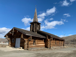 After the Quilchena Hotel, we stopped at Our Lady of Lourdes Catholic Church. This log church with its beautiful steeple just captures the imagination but unfortunately we have not been able to find many details regarding its history. If you have some information please leave me a comment below. We would love to know more about this unique place of worship.  One more gate... One more gate... Now it was time to really leave the road. Just before Stump Lake we turned onto a gravel road called Old Kamloops Rd. At this point Tony turned to me and said, "You may have to get out and open a few gates!" Old Kamloops Rd cuts through numerous ranches including Stump Lake Ranch. We were there just at the start of calving season and were fortunate to spot a few early calves dotting the fields. At the height of the road you get a beautiful view of Stump Lake below. And if you look closely you can see the ice-fishing sheds on the still frozen lake. 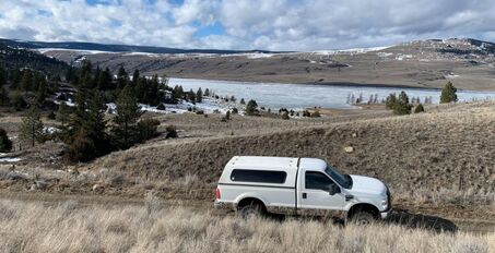 High above Stump Lake  All too soon the drive ends and we're back on pavement. After checking into our hotel we decided to take advantage of the twilight and head north to look for big horn sheep. The Lac du Bois Grasslands, home to mule deer, black bear, white-tail deer, moose and bighorn sheep, is a large protected area on the north side of Kamloops Lake and west of the North Thompson River. We drove until this beautiful lookout, overlooking Kamloops Lake. Someone has set up a beautiful memorial here and they couldn't have found a more serene location. 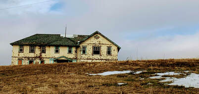 As we were coming back down the mountainside, we noticed a large cluster of buildings, like a small village... but only one light was on. It looked like a ghost town. Tony remembered that his brother had mentioned something unusual about the site but he couldn't recall what it was. Of course, being the person I am, I started researching the moment I was back to my laptop. It didn't take long to find; the story is fascinating and just a little creepy. In the 1900s the "white plague", better known as tuberculosis, was an epidemic. In answer to the crisis, the BC government built the King Edward VII Sanatorium. A community was created around the facility, including gardens, staff residences, gym, firehall and more. This village was named Tranquille. After caring for hundreds of patients, the sanatorium closed in 1958, but reopened a year later as a facility for the mentally ill. In 1983 it was closed permanently. Since then the stories and legends of Tranquille have fueled imaginations. Some going so far as to call Tranquille "the most haunted place in Canada!" Before COVID, Tranquille Farm Fresh offered tours and "escape room" opportunities inside the tunnels that run underneath the immense property. Makes me creeped out just thinking about it. If this is your cup of tea, then you'll love this place. We couldn't get very close but, with my telephoto lense, I managed to get a few spooky shots. Thanks for joining us on this little road trip to Kamloops. We know there's much more to do and so much history to learn but that will have to wait until the next time.
Tony & Dawnelle This trip's links to Kamloops:
Back to Blog
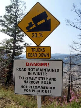 The day was blistering hot. We were on a gravel road that was full of twists & turns and, in many places, only wide enough for one vehicle. On one side of the road the mountain was rugged and steep and on the other side, it was straight down to the Fraser River. As Tony navigated our 4x4, sometimes through spaces that seemed smaller than our beast of a truck, I reminded myself that we were doing this for fun. This particular trip was our annual Anniversary trip and we decided to attempt a back-roads loop that had been on our "to-do" list for a long time. This road trip takes you past some of the most amazing views of the Fraser River but it is not a trip for an inexperienced driver or, for that matter, anyone with a fear of heights! The entire loop is about 125 kilometres; from Clinton to the Big Bar Reaction Ferry, south along the High Bar Road that parallels the Fraser River, east through Edge Hills Provincial Park and then back up to Clinton. The last leg of this loop is the most treacherous part. Six switchbacks up a 23% grade. They've put a sign at the beginning of the switchbacks. It pretty much sums up this road trip for me. We were just starting up the mountain when we saw something ahead, glinting in the sun. "Oh no." Tony said. "This is not good." A few moments later we saw a man walking down the road. When he saw our truck he began to wave his arms, frantically imploring us to stop. It was his car that we saw, broken down in the middle of this desolate spot. You have to understand... this place is remote. We had been driving for over three hours and we never passed another vehicle. When we arrived, the look of utter relief on Chris' face was very apparent. We were his only hope to get out of a very bad situation. 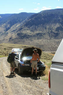 Tony and Chris worked on his Volvo for over an hour. It was 38 degrees, the sun was relentless and so were the flies. To his credit Tony worked hard, trying to reattach the radiator hose that had been ripped to shreds. When it was apparent that it couldn't be fixed we took our new friend to Clinton where he found a motel and a tow truck driver that was willing to go back and rescue the poor car. Chris sent me an email a few days later and thanked us again for rescuing him. If we hadn't come along I'm not sure what he would have done. Don't Worry. I'll be Fine. Nothing is Going to Happen to Me.
Fast forward to this last weekend. We were anticipating a quick little get away to Merritt. Some hunting and geo-caching. Doing what we love to do. That Sunday night Tony was driving in the mountains above Merritt when, suddenly, he saw a young girl coming down the mountainside, running towards the truck. "Oh no." he said. "This is not good." "Please," she said to Tony, "I left my friend up on the mountain. She broke her foot and couldn't go any further. I was going for help." They drove back up the mountain and found the injured girl sitting, waiting for someone to come rescue her. When she saw her friend climb out of our truck she was overwhelmed with relief. She was expecting to wait for hours for her friend to come back with help and was getting pretty worried about spending a very cold night alone, high up in the Merritt grasslands. After Tony helped her into the truck and they started to make their way down the mountain he decided to say what was on his mind. "Look" he said. "I have three daughters about your age and I'm going to tell you what I would say to them right now. I'm looking at what you have and all I see is a couple of little fanny packs and two bottles of water. You have no emergency equipment. Nothing that would help keep you safe during a night alone in the elements. What would you have done if I hadn't come along?" The drive to their car took about 45 minutes and he gave them a lecture the entire way. I'm sure that they are words they will never forget. At least I hope so. Don't Worry. I'll be Fine. Nothing is Going to Happen to Me. Unfortunately these aren't isolated incidents. It seems that you can't turn on the news without hearing about another outdoor enthusiast that has been lost to the wilderness. Some are rescued and some, tragically, are still lost. So this post is for all of you who love to be out there like we do. It's for you who love this great and gorgeous wilderness that we are lucky enough to call home. And it's for you who come to visit. Don't take this land for granted. Go out there and have a great time but please, be prepared for whatever may happen because... We do worry. You might not be fine. And it could happen to you.
Back to Blog
Finally... Haida Gwaii10/15/2011 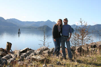 We've been married for 30 years. Yeah us!! And for most of those 30 years we've talked & dreamed about making a trip to the Queen Charlotte Islands (now Haida Gwaii). As our 30th Anniversary drew closer we thought... "What better reason did we need?" Celebrate 30 years of marriage & exploring British Columbia by going on the ultimate road trip! So the planning began. Those of you who know us know that we don't go anywhere without a plan & without doing a lot of research ahead of time. For us that's half the fun! If you're reading our blog right now because you're thinking of a trip to Haida Gwaii I hope you'll find this entry useful & helpful. I've written it with some how-to's, recommendations & must-do's!! 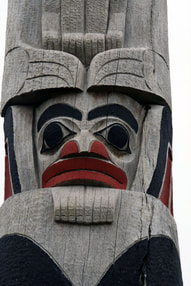 Before we left on our trip there were a few things we needed to do ahead of time. We reserved our spots on the ferry for there and back. Since the trip there was an overnight run we also booked a sleeping berth. I was very pleasantly surprised at our cozy little room on the Northern Expedition. With our own TV & bathroom and very comfy beds we actually slept a lot better than I expected. Another thing we did was book all our accommodations. We decided that we wanted to move around and explore different areas of the island so we reserved three different places - the Hecate Inn in Queen Charlotte City, the Sand Dollar cabin at North Beach Cabins near Massett and for the last three nights we stayed at Chateau Lawnhill in Lawnhill. The last thing we did (OK..I did) was put together a "Our Trip to Haida Gwaii" binder complete with copies of email correspondence, ferry confirmation numbers, special places we wanted to see and even a copy of tide table on the dates we planned to be there. 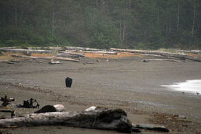 Exploring Haida Gwaii was like being on the pages of a National Geographic magazine. Everywhere we went we were struck by beauty. I think Tony got very tired of me saying... this is soooo beautiful! But it was true. We spent a week exploring from one end of Graham Island to the other. Here are some of our favourite spots... RENNELL SOUND Almost everything we read about Haida Gwaii said don't miss Rennell Sound so we figured that we'd better make sure to go there. Well the books weren't wrong. We went to the sound on our first day on the island. We sure enjoyed the drive there....driving through beautiful forests on gravel roads has always been one of our favourite pastimes! We knew that there was a steep hill at the end of the drive but Tony managed the 24% grade like a pro! After the hill we continued on to the trail head for Gregory Beach. I was excited to learn that there was a cache hidden on this trail... just another bonus for visiting here. After we found the cache (GCX55R) we continued on down the trail to the ocean. Wow is all I can say! Rennell Sound is the only west coast beach on Graham Island that is accessible by road and apparently one of the best beach combing beaches on the entire west coast of North America. We didn't find anything special that day, no beautiful sea shells and no coveted glass fishing floats, but we did see an enormous black bear walking along the beach ahead of us. A once in a lifetime experience!  sad end to Kiidk'yass sad end to Kiidk'yass THE GOLDEN SPRUCE A beautiful legend & a mystery all rolled into one....that is the story of Kiidk'yass or the Golden Spruce. Kiidk'yass was a tree with a rare genetic mutation that made its needles yellow. For centuries the Haida Nation had revered Kiidk'yass as a mythical force. sitting on the banks of the Yakoun River, it was a thing of beauty and according to the Haida, would be there till the end of generations. Then in 1997 an eco-terrorist named Grant Hadwin cut the tree down as "a wake-up call" against industrial logging. The logic of this act escapes me but that is not the end of the story. Released on bail, Grant Hadwin disappeared while on the way to his trial. His broken, abandoned kayak and belongings were found on a remote island but no trace of Hadwin was ever found or has been found since. Fortunately, about 20 years previous, cuttings had been taken from Kiidk'yass by a group of botanists from UBC. After the Golden Spruce was felled, UBC offered one of the new golden saplings to the Haida people which they accepted and planted near the base of the original tree. Today, beside the Yakoun River, you can still see the once mighty tree, now lying on its side, with a brand new yellow spruce planted at its roots. The 10 minute walk to the Golden Spruce is accessed from the road to Juskatla and takes you past some of the most amazing old growth forest we have ever seen.  NORTH BEACH We arrived at our cabin on the very northern end of Graham Island on a beautiful sunny day... perfect timing to explore this amazing area. If you love long walks along the ocean (like me) then this is the place for you... sandy shoreline as far as the eye can see. Just to put it in perspective -- Long Beach, on Vancouver Island, is about 25km long. The continuous length of sandy beaches on Graham Island starts at Massett, continues all along the north coast, around Rose Spit and down to Tlell on the east coast, approximately 100 kms of sandy beach. Incredible and just waiting to be explored.  At the base of Tow Hill At the base of Tow Hill TOW HILL & NAIKOON PROVINCIAL PARK Tow Hill, on the northeast end of Naikoon Provincial Park is a volcanic plug that stands out above the tree line, easily seen from miles away. The 45 minute hike to the top is an easy one since the entire trail is a boardwalk! First time I've ever seen that. At the top you're rewarded with a view that is awe-inspiring.. .and on a clear day you can see Alaska. Really.  Standing on the Juskatla Canoe Standing on the Juskatla Canoe THE WRECK OF THE PESUTA The Pesuta Shipwreck was the one "must-do" that we never made it to. Weather, time constraints and high tides all made it a little difficult to get to but we have some friends who went there this summer and they really enjoyed the hike there and exploring the wreck. HAIDA CANOE It's one thing to see history in a glass case or read about it in a book. It's an entirely different thing to see it and touch in the middle of the rainforest. That was our experience when we hiked to one of 4 Haida canoes that have been abandoned on Haida Gwaii. No one knows why these half finished canoes were left to rot but they were. Were they not carved properly? Did they crack? It's a mystery and we love mysteries. You'll find the trail head for the Juskatla Canoe at N53 36.145 W132 16.913 and the canoe at N53 36.121 W132 16.701. HAIDA HERITAGE CENTRE This 26 million dollar museum & Heritage Centre in Skidegate is incredible. From the huge authentic totems to the tiny baskets woven with spruce roots... well worth the $15 entrance fee. 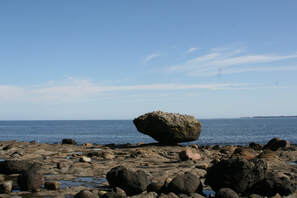 BALANCE ROCK Balance Rock is a huge glacial erratic just north of Skidegate that sits perfectly balanced on the point of another rock in the middle of a beach near Skidegate. You've got to see it to really appreciate it. 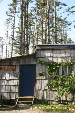 There are many places to stay on Haida Gwaii... from campsites to B&Bs. The pitfalls of reserving a place through a website is that you never know if it's as good as it looks in the pictures! We were fortunate to find three wonderful accomodations and I'd highly recommend each one of them. HECATE INN in Queen Charlotte City was clean and quiet. We had our own apartment with a separate bedroom and kitchen which was great for making our own meals. They also had internet access which can be pretty important if you need to keep in touch with your family. NORTH BEACH CABINS was the most rustic of the three places we stayed. The Sand Dollar, which was our cabin, had no electricity but it was cozy with a propane stove & heater and the incredible North beach was only minutes away. Lisa, our host, has added all sorts of beautiful touches to make her place special... even stained glass windows in the outhouses! CHATEAU LAWNHILL was the last place we stayed and from the moment we arrived Ron, our host, made sure we felt at home. We appreciated all the advice he gave us for exploring the island and sure enjoyed the huge salmon steaks he brought us!  Before we knew it our week had come to an end and it was time to head home. We really hated to see it come to end... there was so much more we would have liked to see but well, reality beckons.
The wonder & beauty of Haida Gwaii is not something we will soon forget. It truly was the trip of a lifetime.
Back to Blog
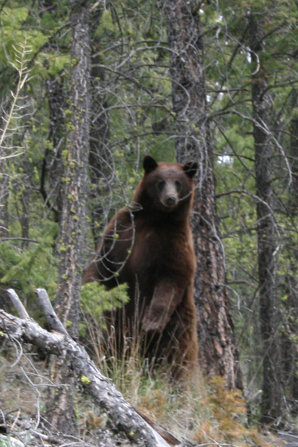
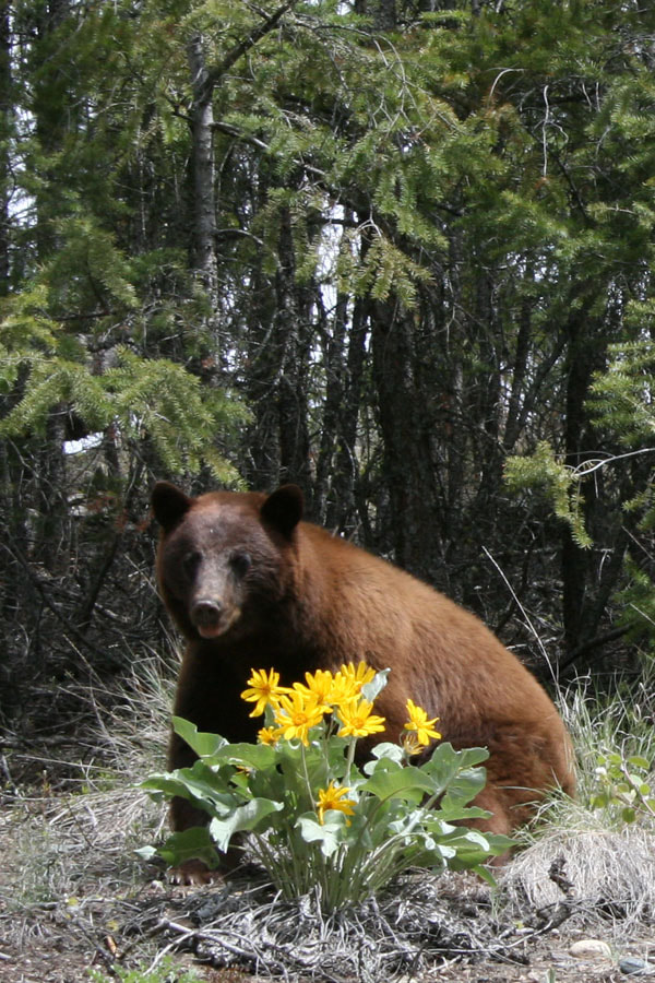
The Other Day, I Met a Bear5/13/2008 To say that my husband is an outdoorsman is like saying Tiger Woods golfs once in a while. The man that I married eats, sleeps & thinks about being outside. If he's not out there hunting, fishing, scouting, or hiking he's planning the next time that he will be. Of course when you put in the time, you're bound to have more than your fair share of animal encounters. A few weeks before our wedding Tony managed to crack two ribs escaping from a sow black bear with two cubs. Then there was the black bear that decided to use him as a punching bag. When he arrived home that time he was covered in blood, but still standing! Usually I am the recipient of these tales long after the fact. He has this amazing ability to weave a story as he elaborates on every detail. I can listen to him tell the same ones over and over. But once in a while I get to see it for myself. We had been camping at Barnes Lake with friends and were on our way back from a little side trip to Oregon Jack Provincial Park (we went to see the pictographs there). We had just rounded a corner when Tony said, "There's a bear!" I was still processing the word 'bear' as he was making his way up the mountainside with our new camera. At first it seemed as if the bear would disappear in a hurry. In fact it stood on its hind legs and huffed quite a bit. I take this as a bad sign. To Tony that's a sign to get closer. But suddenly the bear seemed to have a change of heart, deciding rather to pose for a spread in Outdoor Life. Slowly it meandered to a stump and put its elbows on top. "How about this?" "No? Something softer? A little prettier? These flowers look nice. Let me sit behind them." We probably stayed and took pictures and watched him for about 1/2 hour while he gave us ample opportunity to take these amazing photographs. Of course my favourite is the one of my outdoorsman and his 'voguing' bear. 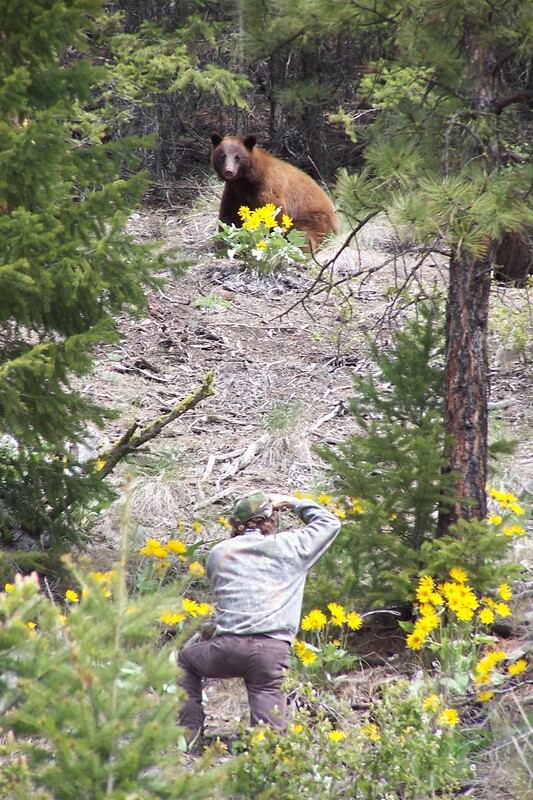 |
DAWNELLE GUENTHER
 RSS Feed